兩封來自地政總署的電郵回覆
一是問有關「香港與其鄰近地區」地圖上海拔高度的資料,因為香港跟內地是用不同的高程標準,理應不能直接比較,我問對方有沒有將內地的數字轉成本地基準,得到的答覆如下:
Dear Mr. Harold CHAN,
Thank you for your email.
I am pleased to inform you that, on the map "Hong Kong in Its Regional Setting", height of hills in mainland China refer to the mainland standard.
Best regards
KH Leung
Senior Cartographer
也就是說,梧桐山頂高 944 米並不等於香港海拔 944 米。
另外,我之前留意到,在香港大地測量基準說明提到的香港高程基準和 WGS84 基準轉換如下:
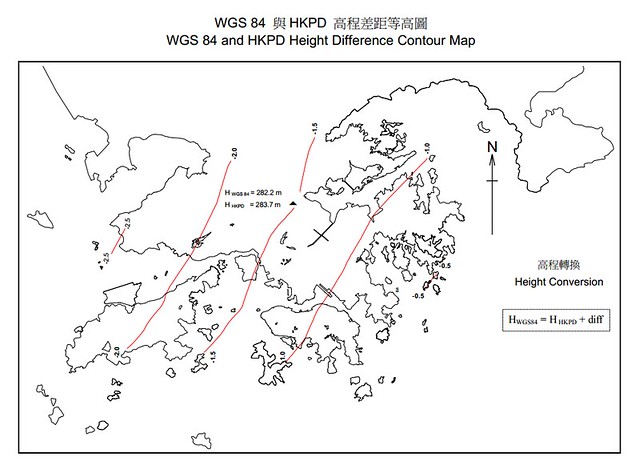
但我以 Control Points for Height Model of Hong Kong (Version 1.0),卻發現兩者的差距如下,有比較大差距:
得到的回覆如下:
Dear Harold
"Control Points for Height Model of Hong Kong (Version 1.0)" is more accurate.
The "Explanatory Notes on Geodetic Datums in Hong Kong" was published in 1995, the stated WGS84 heights are reference to the GPS survey conducted by British forces 512 Specialist Team Royal Engineers in 1991 (STRE91). On the other hand, "Control Points for Height Model of Hong Kong (Version 1.0)" is reference to the International Terrestrial Reference Frame 1996 (ITRF96).
Satellite geodesy has great advancement over the years. Generally speaking WGS84 (STRE91) and ITRF96 are more or less the same, they are both geocentric reference system, the origin is the Earth’s centre of mass. The difference of the two systems, at Hong Kong, the horizontal offset is about 0.3m and 2m in height.
Hong Kong adopted ITRF96 as our geodetic reference frame coordinates in early 2000s. As WGS84 is a more common term, so we often say WGS84 coordinates. In more accurate and scienific senses, we will specify ITRF96
Please contact me if you have further queries.
Thank you.
SO Mo Kan
PSO/G
Geodetic Survey Section
Lands Department
即是 Control Points for Height Model of Hong Kong (Version 1.0) 是比較準確的。對方提出一點幾好,是 WGS84 是普遍使用的字眼,而加上 ITRF 這個框架標準會描述得更準確。
參考資料:
Simon Chi-wo KWOK - The Hong Kong GPS Network and Reference Stations
內部連結:
為什麼不同基準之間的海拔高度不能直接轉換?
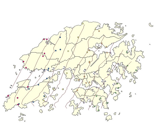
試用 Quantum GIS - 香港基準高程與 WGS84 高度差的分佈
【目錄】地理/地理資訊系統/空間資料庫/大地測量內部連結
本文連結