試用 GeoServer - 加入香港海拔數據
先匯入到存儲,再加入到圖層區,再利用 SLD 將 Raster 數據轉換成等高線數據,在圖層區輸出,要注意的是此功能需要比較多記憶體容量,在啟動 Java 前先將相關的設定調高:

SLD 內容:
<?xml version="1.0" encoding="ISO-8859-1"?>
  <StyledLayerDescriptor version="1.0.0"
    xsi:schemaLocation="http://www.opengis.net/sld StyledLayerDescriptor.xsd"
    xmlns="http://www.opengis.net/sld"
    xmlns:ogc="http://www.opengis.net/ogc"
    xmlns:xlink="http://www.w3.org/1999/xlink"
    xmlns:xsi="http://www.w3.org/2001/XMLSchema-instance">
    <NamedLayer>
      <Name>contour_dem</Name>
      <UserStyle>
        <Title>Contour DEM</Title>
        <Abstract>Extracts contours from DEM</Abstract>
        <FeatureTypeStyle>
          <Transformation>
            <ogc:Function name="gs:Contour">
              <ogc:Function name="parameter">
                <ogc:Literal>data</ogc:Literal>
              </ogc:Function>
              <ogc:Function name="parameter">
                <ogc:Literal>levels</ogc:Literal>
                <ogc:Literal>50</ogc:Literal>
                <ogc:Literal>100</ogc:Literal>
                <ogc:Literal>150</ogc:Literal>
                <ogc:Literal>200</ogc:Literal>
                <ogc:Literal>250</ogc:Literal>
                <ogc:Literal>300</ogc:Literal>
                <ogc:Literal>350</ogc:Literal>
                <ogc:Literal>400</ogc:Literal>
                <ogc:Literal>450</ogc:Literal>
                <ogc:Literal>500</ogc:Literal>
                <ogc:Literal>550</ogc:Literal>
                <ogc:Literal>600</ogc:Literal>
                <ogc:Literal>650</ogc:Literal>
                <ogc:Literal>700</ogc:Literal>
                <ogc:Literal>750</ogc:Literal>
                <ogc:Literal>800</ogc:Literal>
                <ogc:Literal>850</ogc:Literal>
                <ogc:Literal>950</ogc:Literal>
                <ogc:Literal>1000</ogc:Literal>
              </ogc:Function>
              <ogc:Function name="parameter">
                <ogc:Literal>interval</ogc:Literal>
                <ogc:Literal>50</ogc:Literal>
              </ogc:Function>
            </ogc:Function>
          </Transformation>
          <Rule>
            <Name>rule1</Name>
            <Title>Contour Line</Title>
            <LineSymbolizer>
              <Stroke>
                <CssParameter name="stroke">#000000</CssParameter>
                <CssParameter name="stroke-width">1</CssParameter>
              </Stroke>
            </LineSymbolizer>
            <TextSymbolizer>
              <Label>
                <ogc:PropertyName>value</ogc:PropertyName>
              </Label>
              <Font>
                <CssParameter name="font-family">Arial</CssParameter>
                <CssParameter name="font-style">Normal</CssParameter>
                <CssParameter name="font-size">10</CssParameter>
              </Font>
              <LabelPlacement>
                <LinePlacement/>
              </LabelPlacement>
              <Halo>
                <Radius>
                  <ogc:Literal>2</ogc:Literal>
                </Radius>
                <Fill>
                  <CssParameter name="fill">#FFFFFF</CssParameter>
                  <CssParameter name="fill-opacity">0.6</CssParameter>
                </Fill>
              </Halo>
              <Fill>
                <CssParameter name="fill">#000000</CssParameter>
              </Fill>
              <Priority>2000</Priority>
              <VendorOption name="followLine">true</VendorOption>
              <VendorOption name="repeat">100</VendorOption>
              <VendorOption name="maxDisplacement">50</VendorOption>
              <VendorOption name="maxAngleDelta">30</VendorOption>
            </TextSymbolizer>
          </Rule>
        </FeatureTypeStyle>
      </UserStyle>
    </NamedLayer>
   </StyledLayerDescriptor>
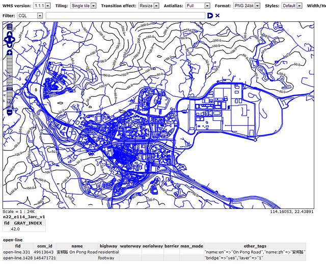
結果如下:
參考連結:
GeoServer Docs - Rendering Transformations
OpenGeo Suite Library - Creating a contour map with a WPS process
內部連結:
【目錄】地理/地理資訊系統/空間資料庫/大地測量內部連結
本文連結